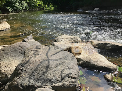
local circle Fire charcoal with stone, Water, Air, Fire, Earth & Ethers
Shawangunk Kill
Shawangunk NY
7/31
∆ ∆ ∆
stabilizing balance
creative expressions
activating changes
from confluence with Wallkill/Gardiner Shawangunk Kill to Pine Bush access posted private land... with map marked " Watchtower is a hamlet (and census-designated place) located in the Town of Shawangunk, Ulster County, New York, United States. The population was 2,381 at the 2010 census. It is owned and operated by the Watchtower Society (a legal entity of Jehovah Witnesses) and has been in operation since 1963.[2]" https://en.wikipedia.org/wiki/Watchtower,_New_York
"...Shawangunk was first settled by Europeans during the 1680s. The region was first designated a precinct about 1710, and became the township of Shawangunk in 1788. The town's name comes from the Dutch transliteration of the Munsee Lenape name or phrase. The approximate Lenape pronunciation was "Sha-WAN-gunk," probably meaning "in the smoky air." The name first appears in the 1682 Indian deed to Gertrude Bruyn. It is uncertain if this was the Indians' actual proper name for their nearby village and "New Fort," destroyed by the Dutch on Sept 5, 1663 during the Second Esopus War, or if the name was merely a phrase invented by the Indians in connection with the Bruyn land purchase, possibly describing some temporary feature of the landscape. Suggestions as to whether the name may have referred to smoky conditions on the day of Bruyn's first tour of the land with the Indians in the 1670s, or to the smoky ruins of the destroyed Indian village during the preceding decade, are purely speculative. Use of the name to designate the creek on which Bruyn settled (Shawangunk Kill), and the mountain range, came somewhat later. Locals pronounce the name "SHONG-gum,"[ an obvious[according to whom?] corruption or contraction of the original name, but one on record at least as far back as 1777 (Marc B. Fried, "Shawangunk Place-names" pp. ix-xi, 3-12, 96-97). Present-day citizens of Shawangunk often refer to themselves as living in particular hamlets such as Wallkill or Walker Valley rather than the town as a whole;["
"...The Shawangunk Mountains, primarily consisting of quartz, rise 2,000 feet above the town.[10] The mountains were created over 10,000 years ago during the last ice age when retreating glacial ice carved them out as part the surrounding Catskills,[11] drawing tourists and climbing enthusiasts from all over the world.[12]"...
https://en.wikipedia.org/wiki/Shawangunk,_New_York
"...In the early 1990s, the U.S. Fish and Wildlife Service, when it was researching the fate of the former Galeville air base site (now Shawangunk Grasslands National Wildlife Refuge) found that the lower Shawangunk (from its mouth to Pine Bush) supports an unusually diverse plant and animal community for the region due to the absence of any serious impoundment along the upper river. It reported no less than six species of freshwater mussels, including the rare swollen wedge mussel, and 31 species of fish. Among the latter were the rare Notropis amoenus (comely shiner), Notropis stramineus (sand shiner, Percina caproedes (logperch), Lepomis auritis (redbreasted sunfish) and Noturus insignis (margined madtom
The study found that the region supports the only known community of Diarrhena obovata (beakgrass) in the state. Other rare plants in the lower Shawangunk Kill include threadfoot on submerged ledges, sharp-winged monkeyflower, wingstem and redrooted flatsedge along the stream itself, with Davis' sedge, swamp agrimony, Aster vimeneus (small white aster) and violet bushclover joining the beakgrass in the flood plains. ..."
Due to the minimal development (mostly agricultural) within much of its watershed, there is very little pollution.[2] In 2015 the town council members of Wallkill, through which five miles (8.0 km) of the stream flows, enacted a law to protect the Shawangunk Kill. It bars any construction (including roads), clear cutting, dumping or septic systems within 100 feet (30 m) of the high water mark, Crawford, to the north, also has in place limits on new construction and rebuilding in the stream's vicinity, and in Mount Hope much of the land around it is owned by the municipality. "
- https://en.wikipedia.org/wiki/Shawangunk_Kill
Elements are Life
Love Peace CoCreativity...
art with Earth blog, charcoal, collaborative with Nature, eco-environmental land art, fractals, webh


No comments:
Post a Comment